
Cape Ann, Mass.

July 2007
By Tom Keer
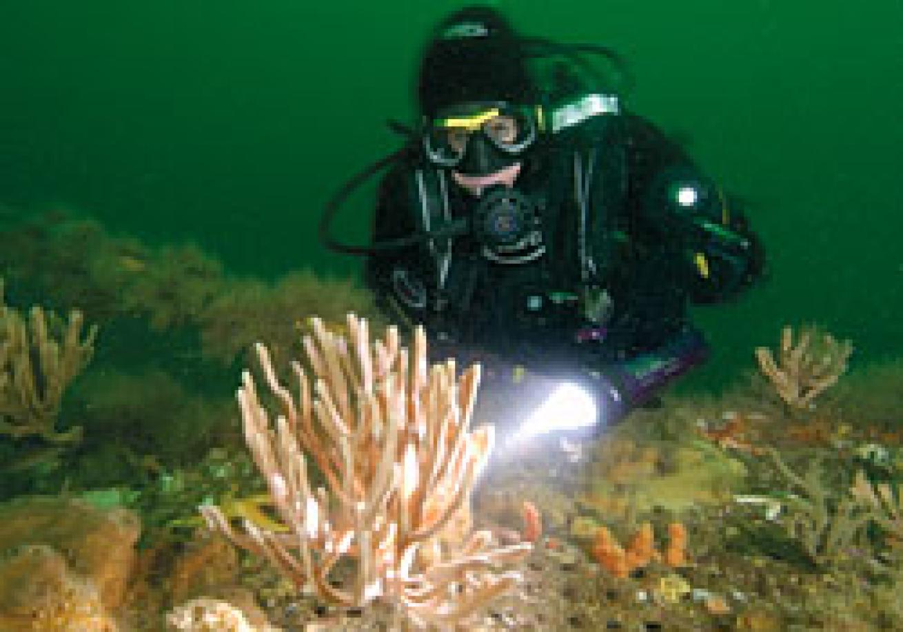
If you've never been diving off the coast of Massachusetts, the water that washes down your spine will seem numbingly cold--even in summer, surface water temps only get into the 60s. But after that initial rush, you can go about the business at hand, because in Gloucester and Rockport, Mass., collectively known as Cape Ann, there are dozens of options for divers.
The 25-mile Cape Ann coastline is one of the Northeast's finest dive spots, and features rocks, ledges, reefs and inshore islands that appeal to photographers, wreck junkies and divers just looking to explore.
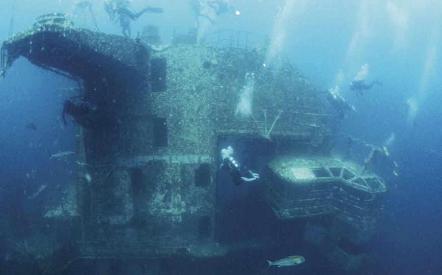
The Wrecks
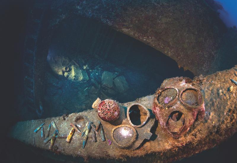
Cape Ann's rugged terrain has claimed hundreds of wrecks over the past few centuries. Most wooden ships are now debris on the seafloor, but two popular dives some 800 yards southwest of Gloucester's Eastern Point are simple workboats gone awry. Though pounding nor'easters, strong currents and harsh winters take their toll on Cape Ann wrecks, these two, the oil tanker Chester Poling and trawler Nina T, are still in good shape.
The Chester Poling sank during a January 1977 storm that split the hull in half and pushed the stern section inshore and the bow section several miles offshore. I like the stern dive for its easy entrance and exit points. The steel hull hasn't corroded, and all the work machinery, namely chafing gear and winches, is intact. Most of the ship has been salvaged over the years, but personal artifacts are still found in the silt basin. An underwater garden of kelp and sea anemones has formed on the Poling's catwalk, while healthy populations of fish, including cod, pollock, fluke and flounder, are reliably found here. The Poling rests upright in 95 feet of water on a sand and silt bottom.
The Nina T is a scuttled fishing trawler, deliberately sunk by divers in 1997. Its wooden hull is showing signs of deterioration, but on my last dive its mast was still erect, covered with barnacles and mussels, and there are purple sea stars and yellow anemones galore. The aft deck is open and entrance to the wheelhouse is simple. Winches remain on the deck, and vises in the stern.
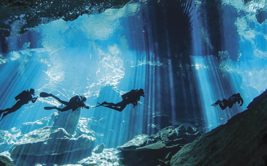
The Shore Dives
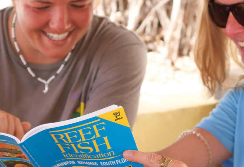
There are dozens of earmarked shore dive sites: Pick an interesting spot, get out and dive. Common activities are lobstering, reef or wall diving, and underwater photography. Two Cape Ann shore dives, Cathedral Rocks and Folly Cove, offer a bit of everything.
Cathedral Rocks in Rockport offers a dramatic drop-off to 75 feet. Lobstering is good to excellent, and you'll find blackfish, striped bass, pollock and bluefish swimming around. Barnacles, mussels, sea stars and various colored anemones cling to the rocks. The green, brown and red seaweeds, and knotted wrack and rockweed found at every depth add a lot of color.
The walk from the parking area to the water isn't long, but carrying tanks and weight belts make the dive better suited to those in good physical condition. Entrances and exits are off the rocks. Look for a break in the rocks and ledges. Step to the edge of the rock, wait for the water to quiet down, and make a giant-stride entrance. Quickly swim away from shore so the following wave set doesn't knock you back. The entrances aren't difficult, they just require some timing; that said, the dive is better suited to divers with at least intermediate-level skills. Winds under 15 knots and quarter moon tides make for softer surges, and currents run north to south. Commercial lobster boats run along the deep-water edges, so be sure to fly your flag.
At Rockport's Folly Cove the cove cuts in around the jagged shoreline, and there's a rocky beach that divers use for entries and exits. The current slows in the protected cove, and many dive shops use this site for certification dives. With the slower current comes outstanding sea life. In the sandy center of the cove are horseshoe crabs, sand dollars, skates and even a torpedo ray or two. (Avoid the ray; they deliver a 220-volt shock.) I usually snorkel to the northwest point of the cove where the drop-off slopes to depths of about 40 feet. Here you'll find abundant marine life, with brown, green and red seaweed and rockweed, sponges, urchins, lobsters, crabs and schools of fish, most notably tautog, striped bass and pollock.
InDepth
Dive Conditions: By the standards of Yankee divers, the water is fine. 6.5-7mm wetsuits are the norm for spring, summer and fall diving. Dry suits get the nod in the winter, but some divers wear them year-round. In the spring, temps are in the 40s to 50s, in the summer, in the 50s to 60s, and in the fall drop to the 40s and 50s. Visibility reaches 50 feet in the colder months and 15 to 25 feet in summer.
Tidal variations are around 10 feet during quarter moons and up to 13 feet during full and new moons. Dive around the higher watermarks and enter an hour before high tide and exit at slack high tide when the current is the softest. Watch the four-wave-length cycle; one wave in the set is slightly larger than the rest, and get in and out accordingly. Long shore currents can be tricky, but they'll be the softest at slack tide, when the water isn't moving.
Wreck Diving: Two dive shops offer boat dives to the Chester Poling and Nina T: Cape Ann Divers (www.capeanndivers.com) and Undersea Divers (www.underseadivers.com).
Cape Ann Divers is the closest to all the spots, and air fills cost $6. Both shops offer rental gear, and their boat dive schedules can be found on their web sites. They also offer free area shore dives, so if you're traveling alone, it's easy to pair up with a group.
For do-it-yourself boat owners: Chester Poling stern, Lat/Lon: 42-34-25N/70-40-15W; Nina T, Lat/Lon: 42-34.133N/70-40.522W.
How to get to Cathedral Rocks: Take Rte. 128N through Blackburn and then through Grant Circle. At the light, take a left turn onto Rte. 127 to Rockport. At the 5 Corner intersection, stay on 127 by turning left. Follow 127 for about two miles, and turn right onto Phillips Ave. Continue straight to Cathedral Ave. Parking is unrestricted, but limited. It's best to stay on the public area of the street, and outside the landowners' private property signs on each side of the entry area.
How to get to Folly Cove: Take Rte. 128N to Grant Circle (the first rotary, at the Friendly's). Take the third exit from the rotary, onto Rte. 127. After driving about five miles on 127, you'll pass Plum Cove, Lanesville and signs for Annisquam Village. Folly Cove is on your left. There is a small parking area near the granite bench.
More Info: To get more information on other shore dive sites close to Cape Ann, check out www.shorediving.com.
On the web: Check out Dave Clancy's excellent site "Hunting New England Shipwrecks" at www.wreckhunter.net.
Lobsters and shellfish: If you want to hunt lobsters and shellfish, you must have a permit, and you'll need a gauge. Permits are available online through the Department of Fish and Wildlife, www.sport.state.ma.us. Individual regulations apply to hard-shelled clams (littlenecks, cherrystones, quahogs and sea clams) as well as to scallops.
July 2007
By Tom Keer
If you've never been diving off the coast of Massachusetts, the water that washes down your spine will seem numbingly cold--even in summer, surface water temps only get into the 60s. But after that initial rush, you can go about the business at hand, because in Gloucester and Rockport, Mass., collectively known as Cape Ann, there are dozens of options for divers.
The 25-mile Cape Ann coastline is one of the Northeast's finest dive spots, and features rocks, ledges, reefs and inshore islands that appeal to photographers, wreck junkies and divers just looking to explore.
The Wrecks
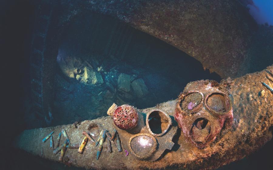
Cape Ann's rugged terrain has claimed hundreds of wrecks over the past few centuries. Most wooden ships are now debris on the seafloor, but two popular dives some 800 yards southwest of Gloucester's Eastern Point are simple workboats gone awry. Though pounding nor'easters, strong currents and harsh winters take their toll on Cape Ann wrecks, these two, the oil tanker Chester Poling and trawler Nina T, are still in good shape.
The Chester Poling sank during a January 1977 storm that split the hull in half and pushed the stern section inshore and the bow section several miles offshore. I like the stern dive for its easy entrance and exit points. The steel hull hasn't corroded, and all the work machinery, namely chafing gear and winches, is intact. Most of the ship has been salvaged over the years, but personal artifacts are still found in the silt basin. An underwater garden of kelp and sea anemones has formed on the Poling's catwalk, while healthy populations of fish, including cod, pollock, fluke and flounder, are reliably found here. The Poling rests upright in 95 feet of water on a sand and silt bottom.
The Nina T is a scuttled fishing trawler, deliberately sunk by divers in 1997. Its wooden hull is showing signs of deterioration, but on my last dive its mast was still erect, covered with barnacles and mussels, and there are purple sea stars and yellow anemones galore. The aft deck is open and entrance to the wheelhouse is simple. Winches remain on the deck, and vises in the stern.
The Shore Dives
There are dozens of earmarked shore dive sites: Pick an interesting spot, get out and dive. Common activities are lobstering, reef or wall diving, and underwater photography. Two Cape Ann shore dives, Cathedral Rocks and Folly Cove, offer a bit of everything.
Cathedral Rocks in Rockport offers a dramatic drop-off to 75 feet. Lobstering is good to excellent, and you'll find blackfish, striped bass, pollock and bluefish swimming around. Barnacles, mussels, sea stars and various colored anemones cling to the rocks. The green, brown and red seaweeds, and knotted wrack and rockweed found at every depth add a lot of color.
The walk from the parking area to the water isn't long, but carrying tanks and weight belts make the dive better suited to those in good physical condition. Entrances and exits are off the rocks. Look for a break in the rocks and ledges. Step to the edge of the rock, wait for the water to quiet down, and make a giant-stride entrance. Quickly swim away from shore so the following wave set doesn't knock you back. The entrances aren't difficult, they just require some timing; that said, the dive is better suited to divers with at least intermediate-level skills. Winds under 15 knots and quarter moon tides make for softer surges, and currents run north to south. Commercial lobster boats run along the deep-water edges, so be sure to fly your flag.
At Rockport's Folly Cove the cove cuts in around the jagged shoreline, and there's a rocky beach that divers use for entries and exits. The current slows in the protected cove, and many dive shops use this site for certification dives. With the slower current comes outstanding sea life. In the sandy center of the cove are horseshoe crabs, sand dollars, skates and even a torpedo ray or two. (Avoid the ray; they deliver a 220-volt shock.) I usually snorkel to the northwest point of the cove where the drop-off slopes to depths of about 40 feet. Here you'll find abundant marine life, with brown, green and red seaweed and rockweed, sponges, urchins, lobsters, crabs and schools of fish, most notably tautog, striped bass and pollock.
InDepth
Dive Conditions: By the standards of Yankee divers, the water is fine. 6.5-7mm wetsuits are the norm for spring, summer and fall diving. Dry suits get the nod in the winter, but some divers wear them year-round. In the spring, temps are in the 40s to 50s, in the summer, in the 50s to 60s, and in the fall drop to the 40s and 50s. Visibility reaches 50 feet in the colder months and 15 to 25 feet in summer.
Tidal variations are around 10 feet during quarter moons and up to 13 feet during full and new moons. Dive around the higher watermarks and enter an hour before high tide and exit at slack high tide when the current is the softest. Watch the four-wave-length cycle; one wave in the set is slightly larger than the rest, and get in and out accordingly. Long shore currents can be tricky, but they'll be the softest at slack tide, when the water isn't moving.
Wreck Diving: Two dive shops offer boat dives to the Chester Poling and Nina T: Cape Ann Divers (www.capeanndivers.com) and Undersea Divers (www.underseadivers.com).
Cape Ann Divers is the closest to all the spots, and air fills cost $6. Both shops offer rental gear, and their boat dive schedules can be found on their web sites. They also offer free area shore dives, so if you're traveling alone, it's easy to pair up with a group.
For do-it-yourself boat owners: Chester Poling stern, Lat/Lon: 42-34-25N/70-40-15W; Nina T, Lat/Lon: 42-34.133N/70-40.522W.
How to get to Cathedral Rocks: Take Rte. 128N through Blackburn and then through Grant Circle. At the light, take a left turn onto Rte. 127 to Rockport. At the 5 Corner intersection, stay on 127 by turning left. Follow 127 for about two miles, and turn right onto Phillips Ave. Continue straight to Cathedral Ave. Parking is unrestricted, but limited. It's best to stay on the public area of the street, and outside the landowners' private property signs on each side of the entry area.
How to get to Folly Cove: Take Rte. 128N to Grant Circle (the first rotary, at the Friendly's). Take the third exit from the rotary, onto Rte. 127. After driving about five miles on 127, you'll pass Plum Cove, Lanesville and signs for Annisquam Village. Folly Cove is on your left. There is a small parking area near the granite bench.
More Info: To get more information on other shore dive sites close to Cape Ann, check out www.shorediving.com.
On the web: Check out Dave Clancy's excellent site "Hunting New England Shipwrecks" at www.wreckhunter.net.
Lobsters and shellfish: If you want to hunt lobsters and shellfish, you must have a permit, and you'll need a gauge. Permits are available online through the Department of Fish and Wildlife, www.sport.state.ma.us. Individual regulations apply to hard-shelled clams (littlenecks, cherrystones, quahogs and sea clams) as well as to scallops.