
A Scuba Diver’s Guide to Washington’s Whidbey Island
Brandon ColeA diver fins passed pilings in Fort Casey State Park.
Current is the key to unlocking some of the most colorful, exciting diving in the Pacific Northwest. It’s no secret that marine life is often most remarkable in areas where ocean currents deliver nutrient-rich planktonic soup meals like clockwork to waiting mouths, claws, and tentacles. Divers can benefit too. Those in the know go with the flow. Or ebb, depending on the moon’s mood and the specific geography of the place.
Whidbey Island, north of Puget Sound proper and south of the San Juan Islands, claims some of Washington State’s top scuba sites and is an excellent choice for a two or three-day getaway. Such an escape requires timing the tides—more accurately, researching current predictions—before you splash. You will want to plan your dives for “slack”, the time period between the changing incoming and outgoing tidal exchanges when water movement is at a minimum. Since each site has its own particular profile, let’s take an in-depth look at three marquee dives accessible from shore.
Skyline Wall
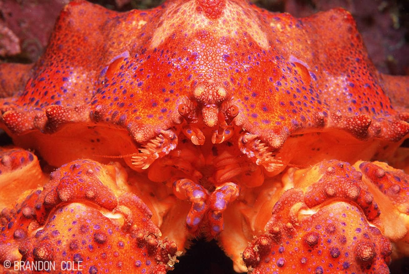
Brandon ColeA puget sound king crab makes eye contact with the author.
Though it does not have the widespread name recognition of Deception Pass and Keystone Jetty, (below), Skyline is a favorite spot among local hardcore photographers and critter hunters. It is located just outside the town of Anacortes on Fidalgo Island, only nine miles away from Deception Pass.
I strive to dive Skyline Wall on every Whidbey Island excursion. Orange, white, red and faintly purple sea cucumbers cover much of the rock surface in the shallows, creating a colorful backdrop that’s a natural for fish photos. Kelp greenlings, rockfish and red Irish lords are abundant. I’ve also encountered juvenile wolf eels snaking around above 35 feet. Ledges transition into a sloping wall dropping to a sand bottom at 80 feet. This is a good place to find Puget Sound king crabs, brightly painted juggernauts of the crustacean kingdom. The keen-eyed may also spy candy stripe shrimp living on crimson sea anemones, a beautifully photogenic example of commensal symbiosis. Viz is rarely great here, so a macro lens is your best choice.
Current Events at Skyline Wall: With all of its marine life, including Skyline in your getaway is no brainer. However, it does take a bit of thinking to enjoy this intermediate to advanced site.
First off, the incoming (flood) tide flows not from west to east as one would expect, but instead from east to west. Second, unless you really enjoy kicking against the current for the whole dive or being carried out to sea, you need to plan your dive for the slack before ebb, aka slack high tide. Entering the water about 30 minutes before the predicted slack usually works well. The goal is to receive a gentle push (courtesy of the waning flood tide) from the beach westward to the drop zone at the beginning of the dive, then relax and enjoy the wall during slack, then ride the beginning of the ebb tide back to the beach at the end of the dive. And third, choose days during which the maximum flood tide before slack is between about 1 and 3 knots in strength, and the maximum ebb after slack is between 1 and 2 knots.
Phew! That’s a lot to data to process. The best way to do your first dives at Skyline is to buddy up with someone who has already successfully navigated the rigamaroll of planning and execution and knows the site’s quirks. Please remember that the times and current strengths noted in the current tables are predictions. They are not always accurate. It’s wise to arrive at the dive site early and assess the conditions. If the tides are not doing what they are supposed to be doing, wait a little while. If reality still doesn’t jive with the forecast, stay safe, move on and try Skyline again another day.
Calculating slack at Skyline: Reference the “Green Point” current station using Planyourdive.com and Deepzoom.com, or “Rosario Strait” current station on [Dairiki.org). Another option is “Burrows Pass” current station in the AyeTides app on the iOS mobile platform.
Deception Pass
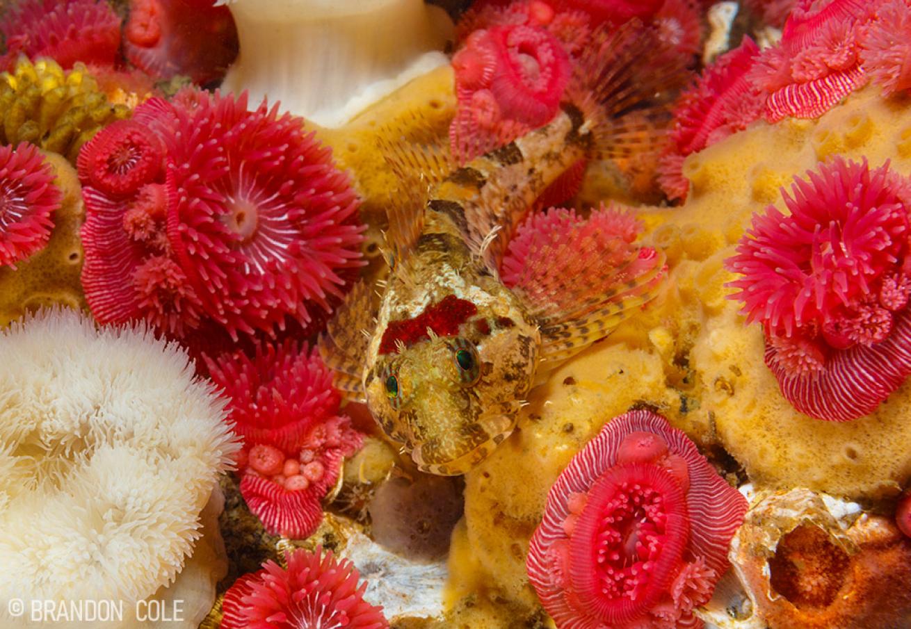
Brandon ColeA scaleyhead sculpin sits among sponges and anemones in Deception Pass.
I would be tempted to do this famed site every day of the year, but alas, it’s a lunar impossibility. The Salish Sea positively screams through Deception Pass at up to 8 knots, so it’s only safe to dive here on select days each year during the most favorable exchanges.
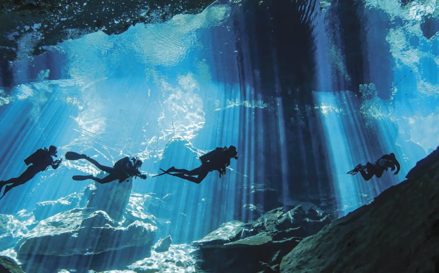
After carefully choosing that special day, my preferred protocol is as follows: Gear up, hike through the trees down to water’s edge at North Beach, swim out to the point and descend. I then keep the wall to my right to explore eastward under the bridge in 25 to 60 feet of water to witness what I believe to be the prettiest reef beneath Washington’s waves. It’s a rainbowed collage of painted dahlia anemones, sponges, sea cucumbers and sea urchins in retina-searing colors so hot you’ll temporarily forget about the chilly 45-to-55-degree water temperature. Clusters of burgundy-plumed feather duster worms adorned with pink brooding anemones are another highlight. Hunkered down in the quilt of filter feeding organisms are sculpins, shrimps, sea stars and sea slugs. Everything here is adapted to holding on for dear life when the current accelerates. Landlubbers on the iconic bridge 200 feet in the sky see only swirling, boiling, racing waters when they gawk downwards. Our view below the surface is infinitely superior.
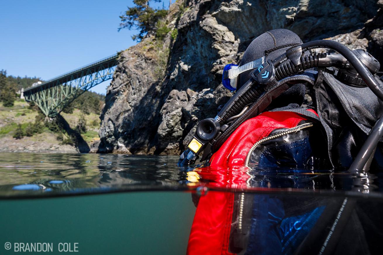
Brandon ColeA diver prepares to descend near Deception Pass Bridge.
Current Events at Deception Pass: The author strongly recommends only undertaking the North Beach shore entry mentioned above during a daytime slack before ebb on an exchange with no more than 10 knots’ swing from max flood to max ebb. Even when targeting theoretically ideal days, exercise extreme caution. Currents are wily creatures, unpredictable at the best of times. The strength of Neptune’s sea winds blowing through Deception Pass is very real and never to be taken lightly. This is not a place to test your training wheels in the drift diving department. One can encounter whirlpools, upwellings, downdrafts and very, very strong lateral currents. It’s common for there to be no true slack window. Instead, the dying flood tide may quickly turn to a formidable ebb without pause.
Work up to Deception Pass by first mastering less challenging dives elsewhere. When your skills are up to the task, take the plunge with a seasoned DP veteran. Enter the water at least 30 minutes early and patiently wait in the cove until you’re certain the incoming flood tide has nearly stopped. Then descend, and hugging tight to the wall at all times, relax and swim or gently drift through the Pass with the last of the flood tide, marveling at the marine life on display. Maintain your buoyancy at a moderate depth.
When the tide turns, don’t fight it. Reverse course and ride the outgoing ebb tide back to the point and then promptly return to the beach. Beware of boat traffic. Consider using a large bottle (I prefer 120 cubic feet) for extra gas on this dive, and be sure to save plenty of air for both the return journey and any unexpected current events. Visibility is often poor in DP thanks to the silty outflows of the mighty Skagit River, but up close and personal, the underwater scenery is unparalleled. Note that some people choose to dive Deception Pass via experienced charter boat to avoid the hike. A live boat following your bubbles also means you don’t need to make the return journey to your starting point.
Calculating slack at Deception Pass: Reference the “Deception Pass (narrows)” current station using Planyourdive.com, Deepzoom.com, Dairiki.org, or the AyeTides app.
Keystone Jetty
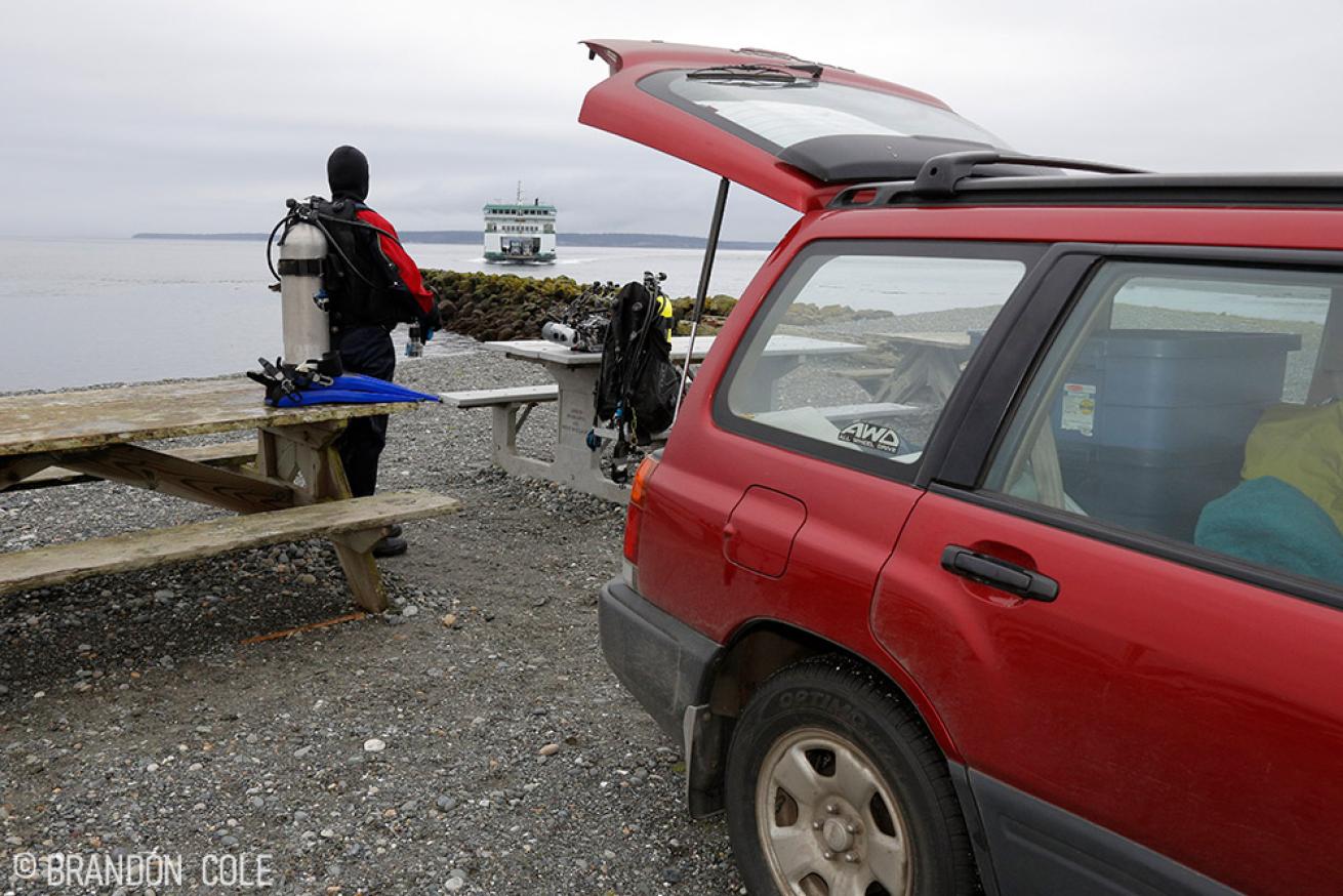
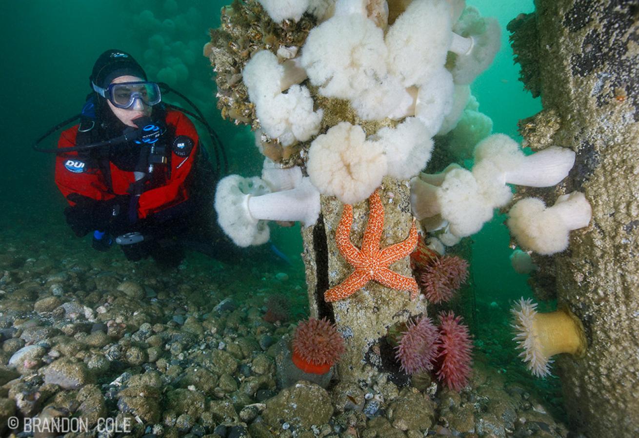
Brandon ColeA scuba diver kits up near Keystone Jetty.
Keystone Jetty in Fort Casey State Park is a cornerstone of the Whidbey Island dive experience and one of the most popular, highly regarded dive sites in the entire state. Thankfully, it’s easier to plan and execute dives here than at either Skyline Wall or Deception Pass. In fact, Keystone is regularly used for scuba courses and can be enjoyed by divers of all skill levels. That being said, there are still current considerations (see “Current Events” below). Keystone offers two distinct dives: the rock “jetty”, and a collection of pier pilings. The jetty—actually a breakwater for the ferry that docks next door—extends from the tideline out to 60 feet deep and is home to a diverse assemblage of fish and invertebrates including ling cod, copper rockfish, perch, giant plumose anemones, mounds of lobed tunicate and swimming scallops, just for starts. The huge lings make quite an impression; some of the lunkers are four feet long and probably 60 pounds, fearless and easy to approach for photos. Overfished on some Washington reefs, the fierce looking beasts and all of their aquatic brethren thrive here because Keystone’s waters are protected.
Across a sandy slope to the east lies the forest of overgrown wooden pilings, the remains of an old wharf in 15 to 30 feet of water. Poking around here you’ll see buffalo sculpins, mottled sea stars, anemones galore, clusters of giant barnacles (look closely in the empty ones to find shrimp, crabs, and fish nestled inside), and so much more. There could even be a giant Pacific octopus or two in residence, stuffed back in one of the pipes on the bottom or lurking under a fallen timber. If luck is on your side, you may encounter this normally reclusive local celebrity out in the open.
My wife Melissa and I once spent an unforgettable hour with an octo whose eight arms must have stretched eight feet wide. We followed the unusually bold GPO as it moved casually about its domain, crawling up and down pilings, ambling through the adjacent kelp bed, and then finally gliding downslope outside the wharf where we reluctantly left it in peace to go about its mysterious business. Was it hunting dungeness crabs? Out on a stroll looking for love? Trying to lure us down to our watery graves? Who can fathom what goes on inside the head of this fascinating creature with nine brains, three hearts, and blue blood. What I do know is that I am powerless to resist the pull of the stunning emerald green waters of Washington’s Inland Sea. With the certainty of the incoming tide, I will soon be drawn back to these same shores for another Whidbey Island weekend.
Current Events at Keystone Jetty: Unless you plan to remain in shallow water immediately next to the jetty (which actually can be quite lovely on a sunny day with the sun streaming through the bull kelp), it’s best to schedule your dive during slack before flood. (It’s possible to extend the diving window into a gentle incoming flood on days with small exchanges.) Enter the water about 60 minutes before predicted slack and stay on the east side of the jetty at all times. Don’t swim around the end of the spit to the west, right into the ferry lane! If you want to venture deeper than about 40 feet, avoid ebb tides, which can drag you around to the west where you don’t want to be. Current inside the cluster of wharf pilings is usually minimal, so this area can make a great second dive after the jetty. But to explore outside the pilings, especially below in deeper water, schedule your splash for slack. Currents can really get cranking below 40 feet, and unlike the jetty’s rockpile, there’s no structure down here behind which to shelter. One more helpful tip: Strong south winds can kick up surf and make Keystone’s normally easy shore entry (and exit) unpleasant, especially at low tide when slippery seaweeds and shifting stones are waiting just underfoot.
Calculating Slack at Keystone Jetty: Reference the “Admiralty Head” current station using Planyourdive.com, Deepzoom.com, and the AyeTides iOS app. Use the “Admiralty Inlet (off Bush Point)” current station on Dairiki.org.