

Robert Ballard, the explorer who found the RMS Titanic, smacks me between the shoulders with a rolled-up magazine. He chuckles triumphantly: “I got it!”
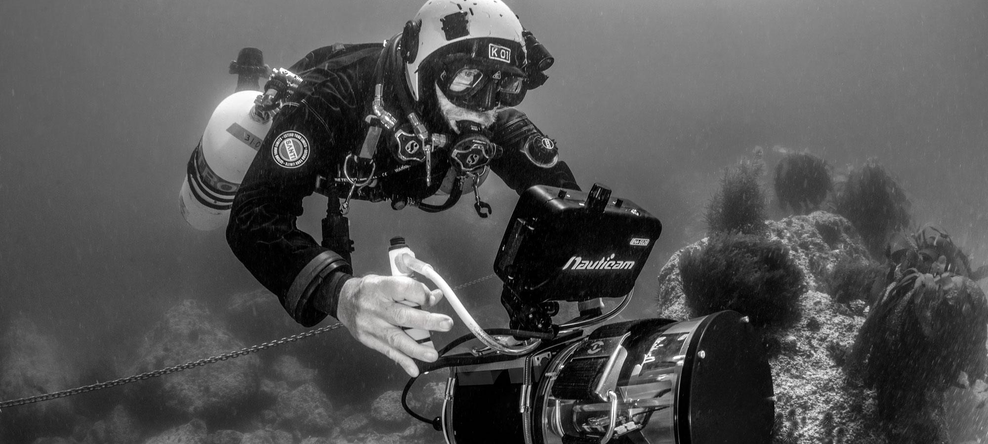
Flies off the California coast are swarming us, and Ballard is doing everything he can to personally put a dent in the population. Camera in hand, I’m here documenting a gathering of engineers, scientists and explorers for a collaborative project sponsored by Ballard’s Ocean Exploration Trust and National Geographic. On the humble dive charter boat Peace are computers, lasers, sensors and an artificially intelligent robot. Fiberoptic cables are strung out from above; rebreathers and assorted dive gear litter the deck. Two software engineers are configuring a pile of cables coming out of the galley. There is no doubt that the vessel’s payload of life-support equipment, 3D scanners and cameras is valued at more than the boat itself.
Ballard is smiling from ear to ear, leading the troops with enthusiasm while passing out a feast of Trader Joe’s gourmet snacks. At 77, this is his 140th expedition. Whether finding Titanic, searching for Amelia Earhart’s plane, or showing school kids live footage of marine life clustered around deep ocean vents, Ballard’s projects are all connected—the technology he uses on one expedition builds capabilities for the next.
This modest mission in the Channel Islands National Marine Sanctuary will offer rewards for future projects well beyond its borders.
With better maps of the world’s oceans, researchers can protect dwindling fish populations, find valuable mineral resources, protect ships and even test equipment proficiency for missions beyond Earth. But all this technology can’t do a thing about the flies.
We’re in the Channel Islands to examine an offshore region called the California Continental Borderland. In this area, caves were carved by the ocean in the period since the Last Glacial Maximum (LGM) about 19,000 years ago. Over a series of dry times on the planet, sea levels paused long enough to create shelflike, paleo-shorelines, or “stands.” At depths of 400, 360, 328, 230, 115 and 33 feet below the present sea level, the water level stopped fluctuating long enough to permit ocean surge to form wave-cut ledges and caves.

Jill HeinerthPeace is a scientific Busytown.
These sea caves likely started as a crevasse or fissure that was exploited by the pounding action of surging water. Scientists hypothesize that humans could have inhabited some of these caves after leaving Beringia to populate the rest of the Western Hemisphere. Currently, the earliest human settlement in western North America is represented by a time when sea levels were 115 feet below present. Finding evidence of human occupation in caves below 115 feet could broaden the story of human migration.
But documenting paleo-shorelines of a much larger continental North America is only one of the lofty goals of the project. These caves offer an opportunity to assess and improve digital mapping technologies. Our team seeks to increase the range, accuracy and speed of new survey devices, and this is the perfect proving ground. Deploying rebreather divers to map a cave by traditional methods takes time, requires perfect weather and presents an envelope of risk, especially when the dives are deep. Ballard is looking at the most innovative and versatile mapping platforms to document the caves quickly, then plans to use these devices on deeper, more remote expeditions.
Jill HeinerthIt's almost surreal to watch Sunfish pause, spin with its thrusters and apparently "think." Hovering in place for a moment, it suddenly springs to life.
A stiff wind stirs up the sea while cave diving explorers Cristina Zenato and Kenny Broad prepare their rebreathers. Aerospace engineer Kristoff Richmond waits at his keyboard while his programming partner takes a break to barf up breakfast. Ocean swells build to a crescendo, and we watch a white, foamy spray explode out of the doorway of a cave on Santa Cruz Island. It is a race to get in as many dives as possible before the escalating surge makes it impossible to dive the cave safely. Every wave stirs up a roiling mess of silt that obliterates visibility; worse, the swell amplifies in the narrow tunnel, pressurizing the cave with a battering ram of seawater that feels like it is crushing our tender ears and sternums. I and others have been sick underwater in the cave, the relentless rocking and pressure change simply too much to bear.
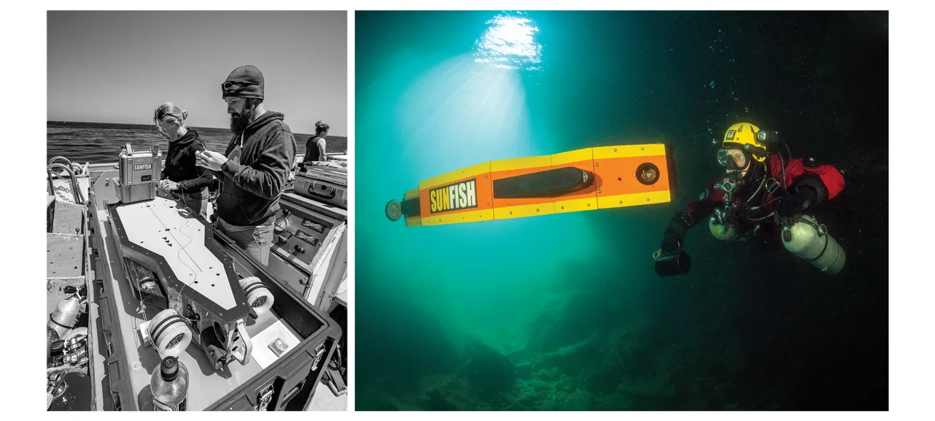
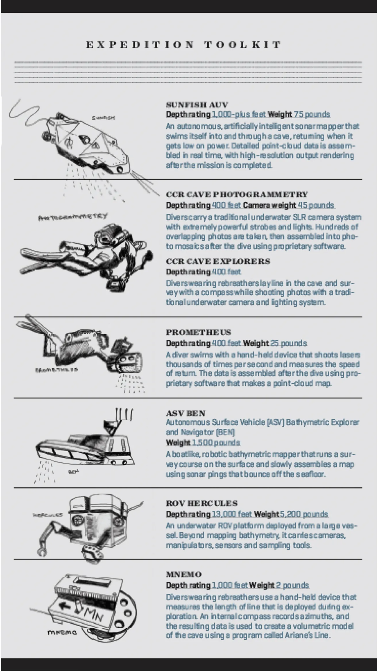
Jill HeinerthTeam members assemble Sunfish, an autonomous, artificially intelligent sonar mapper that can swim itself into and through a cave.
On this dive, we follow the Sunfish autonomous, artificially intelligent mapper past kelp fronds and Garibaldis into the open maw of the cave. A curious California sea lion darts past my camera, casting a sideways glance at the orange-and-yellow robot that has just found a way into the labyrinth beneath the island. This morning’s goal is to navigate into the cave, make a 3D map and return, using only AI for guidance. The mapper drives itself while engineers watch over its shoulder via a fiber-optic cable attached to its stern. Our dive team stays close in case we need to gather up the optical fishing line spooling from behind. It’s almost surreal to watch Sunfish pause, spin with its thrusters and apparently “think.” Hovering in place for a moment, it suddenly springs to life to decisively launch forward, blasting sonar at the walls to stockpile a spray of measurements.
Stopping again, it rotates in place to fill in the blanks of its knowledge and send imagery back to Richmond onboard Peace. Ballard watches over his shoulder, narrating the mission like a sportscaster, already envisioning what we might be able to achieve next. He’s already asking us about our availability in the coming months, eager to explore progressively deeper caves, first using rebreather divers for support, then cutting the cord to let the mapper find caves on its own.

Jill HeinerthGoing over checklists.
In another corner, Massachusetts Institute of Technology post-doc Jake Bernstein tinkers with Prometheus, a hand-held laser-driven mapper that is piloted by a diver to achieve a similar result to Sunfish, but without the expense. It’s one of many new devices from MIT’s Future Ocean Lab. Their goal is to create affordable, high-tech tools for ocean exploration and research.
Bernstein is struggling with a leak in his prototype. Three other engineers offer duct tape, paper towels and Aquaseal. If successful, this device will fire laser pulses several million times a second at the cave walls and measure the speed of return. Light, rather than sonar-generated data points, fused into a cloud with the help of inertial measurement chips and cameras, should produce an image in glorious detail.
While we struggle with calibration, we know this is the first prototype, and setbacks are expected. We’re all confident that future iterations of Prometheus will lead to products that can affordably map reefs, wrecks and the geography of the world’s oceans.
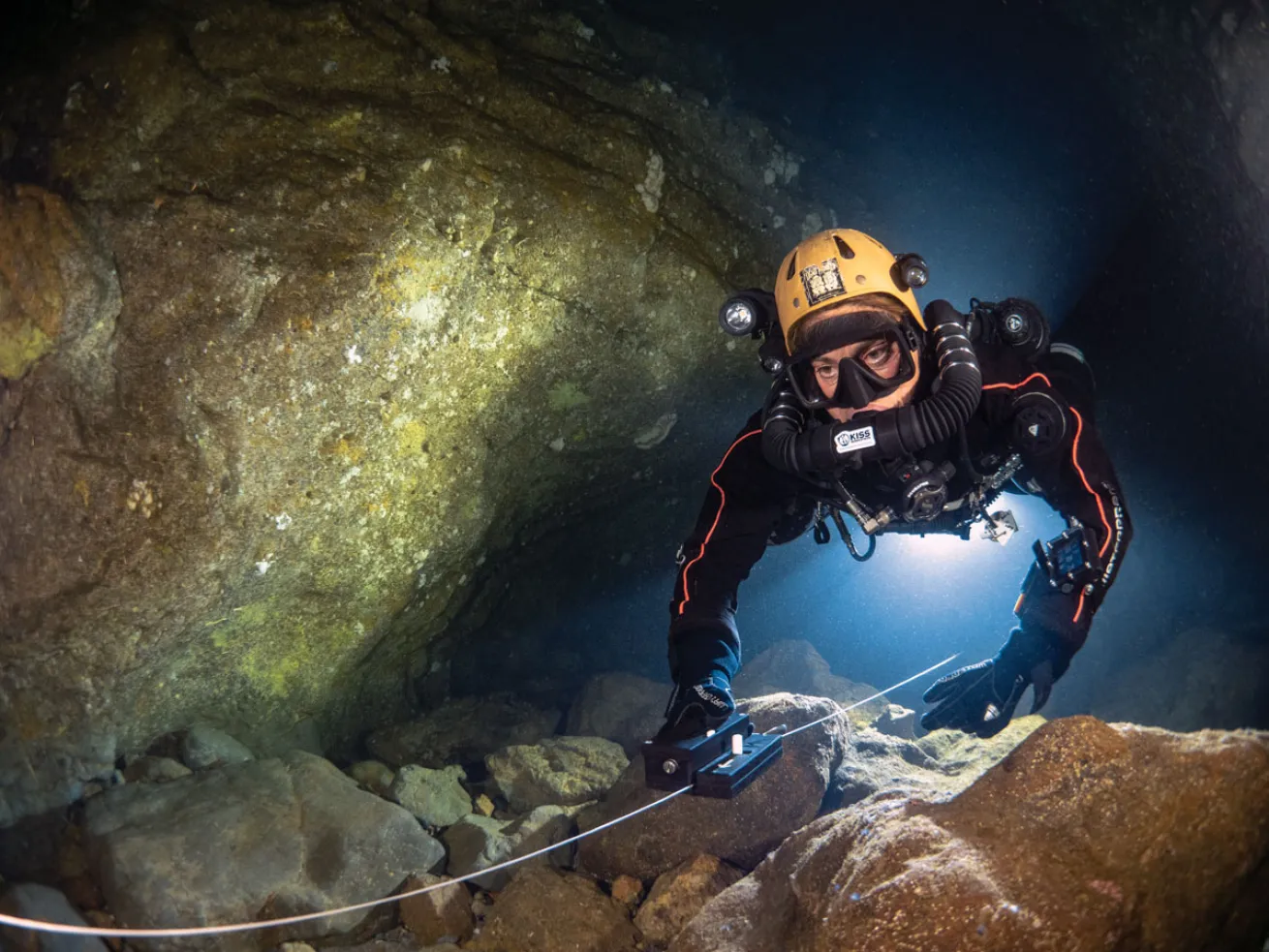
Jill HeinerthA diver with MNEMO, an advanced guide-line measuring tool.
Across from Bernstein, Sebastien Kister vies for the last bit of tabletop for his laptop. He is merging a volumetric model of the cave produced by his MNEMO device with the data stream from Sunfish. His low-tech, diver-held instrument is an advanced guideline measuring tool that a cave diver uses to run and survey an exploration line. Small enough to fit in a diver’s drysuit pocket, MNEMO’s data appears to correlate well with the advanced code streaming out of Sunfish. The two maps align, and Kister sports a rare victorious smile.
Although united in the mission to accurately map this cave, we all understand that our ultimate goal is to make ourselves obsolete. To rapidly and precisely map the world’s oceans and caves, we need to remove the human element and reduce risk.
For now, our jobs are safe. There are many deeper caves to explore, and we will return to document and test gear in new unexplored places. The next step will be to examine undocumented caves 210 feet below the surface. These protected ancient sea caves within the tec-diving zone define the margin of the former continental borderlands and have not been disturbed since the last ice age, time capsules awaiting our exploration.
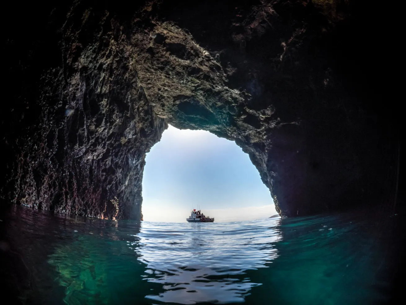
Jill HeinerthThe mission targets California's sea caves as a testing ground.
NEED TO KNOW: CHANNEL ISLANDS
Getting There Kelp forests, caves and coves within the Channel Islands National Marine Sanctuary are best accessed via Santa Barbara, Oxnard and Ventura. Anacapa and Santa Cruz islands are the most popular dive spots, with Garibaldis, bat rays and sea lions sure to offer a show. Colorful anemones, sponges and starfish carpet the rocks, while octopuses and lobsters are usually hiding nearby.
Dive Conditions Extreme winds often create large swells, requiring excellent diving skills and comfort in high seas.
Water Temp Water temperature varies from 50°F in the winter to 70°F in the summer.
Visibility A greenish 30 feet up to 120 feet. When swells create surge, the visibility in the sea caves can quickly degrade to zero. Cave diving is only for extremely experienced individuals with proper training and experience in high surge and low visibility conditions.
Operator Peace Dive Boat


